TV Fool  

Go Back   TV Fool > Special Forums > TV Fool Discussion / Database Updates

Notices

Reply
 
Thread Tools
Old 3-Apr-2019, 1:32 PM   #1
knowlrain
Junior Member
 
Join Date: Feb 2019
Posts: 4
Interactive coverage maps

I've been using the Interactive TV Coverage Browser here: http://tvfool.com/?option=com_wrapper&Itemid=90, and have been looking at the coverage map overlay for each transmitter as described in the help: http://www.tvfool.com/?option=com_co...ask=view&id=67 (section "See coverage map for each station")

That's fine, in that I can see the coverage map for each transmitter. However the section also describes being able to hover over different transmitters in that coverage map to see details like transmitter power, compass direction, etc., in a pop-up balloon.

It's depicted in this image: http://www.tvfool.com/images/stories/station_detail.jpg

I cannot however see how to get a coverage map for multiple transmitters in such a way.

Is this map with several transmitters only available in Google Earth, or am I missing some button somewhere? Thanks
knowlrain is offline   Reply With Quote
Old 3-Apr-2019, 3:54 PM   #2
rabbit73
Retired A/V Tech
 
Join Date: Aug 2012
Location: S.E. VA
Posts: 2,750
Hello, knowlrain; welcome to the forum.

Quote:
Originally Posted by knowlrain View Post
That's fine, in that I can see the coverage map for each transmitter. However the section also describes being able to hover over different transmitters in that coverage map to see details like transmitter power, compass direction, etc., in a pop-up balloon.

It's depicted in this image: http://www.tvfool.com/images/stories/station_detail.jpg
That image is for Google Earth transmitter icons, not Interactive browser.
Quote:
Is this map with several transmitters only available in Google Earth, or am I missing some button somewhere? Thanks
Only Google Earth if you can get it to work; I haven't mastered it yet.

You can get coverage maps, one at a time as you have found out, with the Interactive browser. You can also get FCC coverage maps for any given callsign. For example, WTKR:
https://www.rabbitears.info/

Enter WTKR in Find: Call Sign box and click on search, which will take you here:
https://www.rabbitears.info/market.p...&callsign=WTKR

Scroll down to WTKR and click on Technical Data
Click on RabbitEars TV Query which should take you here:
https://www.rabbitears.info/tvq.php?...ms&facid=47401

Scroll down to WTKR Channel 40
Click on Longley-Rice Coverage Map, which should take you here:
https://www.rabbitears.info/contour....a&site=1&map=Y
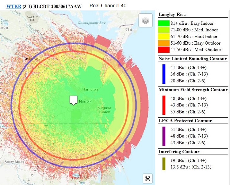
Attached Images
File Type: jpg knowlrainTVFWTKR40FCCcov.JPG (216.0 KB, 4706 views)
__________________
If you can not measure it, you can not improve it.
Lord Kelvin, 1883
http://www.megalithia.com/elect/aeri...ttpoorman.html

Last edited by rabbit73; 3-Apr-2019 at 5:43 PM.
rabbit73 is offline   Reply With Quote
Old 3-Apr-2019, 4:18 PM   #3
knowlrain
Junior Member
 
Join Date: Feb 2019
Posts: 4
Many thanks rabbit73. I've already been learning a lot from your knowledgeable posts here. Looking forward to this forum.
knowlrain is offline   Reply With Quote
Reply

Bookmarks

Tags
details, interactive coverage map, transmitter

Go Back   TV Fool > Special Forums > TV Fool Discussion / Database Updates


Posting Rules
You may not post new threads
You may not post replies
You may not post attachments
You may not edit your posts

BB code is On
Smilies are On
[IMG] code is On
HTML code is Off


All times are GMT. The time now is 9:26 AM.


Powered by vBulletin® Version 3.8.11
Copyright ©2000 - 2024, vBulletin Solutions Inc.
Copyright © TV Fool, LLC